| | Advanced Search


Massachusetts’ Best Communities 2013: #50-#11—Counting down the state's top 50 cities and…

Massachusetts’ Best Communities 2013: #100-#51—The countdown begins today...

Patriots’ Aaron Hernandez questioned in murder case—Not yet a suspect in death of Boston…

Worcester’s Most Memorable Events—Stories for the grandkids...

NEW: Claros Officially Kicks-Off Campaign for State Rep—Single-mother and nurse, Claros decides to "lead by…

NEW: Moore Announces Grant for Worcester for Clean Energy Jobs—Clean energy training for Worcester

Grace Ross: Dreaming of a 21st Century Community—What makes a community great...

Lutheran Social Services Set to Celebrate World Refugee Day—Worcester City Council has named June 20th World…

Central Mass Softball Teams Win All Three State Titles—clean sweep...

Newport Manners + Etiquette: Restaurant Etiquette + More—Picky patrons or constructive criticism?...


BREAKING: Hurricane Sandy Heading For New England

Wednesday, October 24, 2012


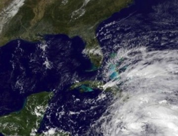
Hurricane Sandy over Cuba: some think this potentially "Perfect Storm" could hit New England early next week. Photo: NOAA.

It’s been well over a year since the leftovers of Hurricane Irene slammed into our area causing general havoc including massive power outages. That was August 28, 2011. Since then there has been little to get worked up over weather-wise, a couple of so-so snowstorms last winter, a few severe thunderstorms and small tornadoes here and there but thankfully no major, widespread weather disasters. In fact, during the past year or so, we have been living in relative “weather heaven” with an unusual amount of sunny, warm days during each of our past four seasons.

Hurricane Sandy: Another "Perfect Storm"?

Now, because of the projections of a few of the many weather prediction mathematical models, there is rampant speculation that New England is about to be hit by a major storm perhaps of the “Perfect Storm” ilk that struck around Halloween in 1991. Right now Hurricane Sandy, a Category 1 hurricane, is a long way away, located south of Jamaica in the Caribbean about 1700 miles to our south. During the next couple of days, it will move over Cuba and into the Bahamas, threatening parts of southern and eastern Florida with hurricane force winds. After that, it is expected to continue to move northward … and this is where it gets sticky. Some data indicates it will move more eastward, away from the U.S. mainland but other just as reliable data is forecasting the storm to gradually lose its tropical characteristics and morph into a massive storm that will turn up the east coast, the center of which could move directly over Southern New England. If that happens, and it is a BIG IF, it would be here early next week. Since the storm would be so large it could well extend over several days, say from Monday through Wednesday. With so much uncertainty in the future track of the storm, it is impossible at this time to fill in any of the details such as how much wind, how much rain, how much, if any, flooding, etc.

The bottom line is that we still have plenty of time to watch, prepare and calculate but, at least, the potential is there. I will have more on this over the next few days, keeping you up to date on the latest developments and forecasts.


Enjoy this post? Share it with others.

Comments:

Stephen Quist

Bring it on!
While the people of the region will be prepared for another storm our utilitiy companies have proven time and time again that they are never prepared.
NSTAR, NATIONAL GRID, etc......care only about their profits not a committment to provide a continuos uninterupted power supply.....
profits before the well being of the people.
flip-flopping mitty quote: "corporations are people too my friends...."
That in a nut shell is the rest of the story


Commenting is not available in this channel entry.