SUNDAY PM STORM UPDATE: John Ghiorse Breaks Down the Latest


Sunday, March 03, 2019
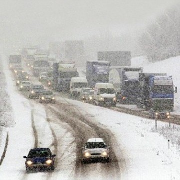
Another fast-moving winter storm is headed in our direction. Heavy, wet snow, typical of March storms, should begin this evening and wind down tomorrow morning. I'm looking for a 5"-9" accumulation across the region, not a "blockbuster" but certainly, enough to make for rough going during the early morning commute tomorrow. Highest totals should be north and west of Providence.
There is still some uncertainty as to how much rain and sleet will mix in during the storm, especially south of Providence. That, of course, would cut back snow accumulation totals in those areas.
The National Weather Service now is predicting:
URGENT - WINTER WEATHER MESSAGE
National Weather Service Boston/Norton MA 1015 AM EST Sun Mar 3 2019
Hartford CT-Tolland CT-Windham CT-Northern Worcester MA- Central Middlesex MA-Western Essex MA-Eastern Essex MA- Western Hampden MA-Eastern Hampshire MA-Eastern Hampden MA- Southern Worcester MA-Western Norfolk MA-Southeast Middlesex MA- Suffolk MA-Eastern Norfolk MA-Northern Bristol MA- Western Plymouth MA-Eastern Plymouth MA-Southern Bristol MA- Southern Plymouth MA-Northern Middlesex MA- Northwest Providence RI-Southeast Providence RI-Western Kent RI- Eastern Kent RI-Bristol RI-Washington RI-Newport RI- Including the cities of Hartford, Windsor Locks, Union, Vernon, Putnam, Willimantic, Barre, Fitchburg, Framingham, Lowell, Lawrence, Gloucester, Blandford, Amherst, Northampton, Springfield, Milford, Worcester, Foxborough, Norwood, Cambridge, Boston, Quincy, Taunton, Brockton, Plymouth, Fall River, New Bedford, Mattapoisett, Ayer, Foster, Smithfield, Providence, Coventry, West Greenwich, East Greenwich, Warwick, West Warwick, Bristol, Narragansett, Westerly, and Newport 1015 AM EST Sun Mar 3 2019 ...WINTER STORM
WARNING REMAINS IN EFFECT FROM 7 PM THIS EVENING TO 10 AM EST MONDAY... * WHAT...Heavy snow. Total snow accumulations of around 5 to 8 inches expected. *
WHERE...Portions of northern Connecticut, western, central, eastern, northeastern, and southeastern Massachusetts, as well as all of Rhode Island. * WHEN...From 7 PM this evening to 10 AM EST Monday. *
ADDITIONAL DETAILS...Travel could be very difficult. The hazardous conditions could impact the morning commute.
PRECAUTIONARY/PREPAREDNESS ACTIONS... A Winter Storm Warning for snow means severe winter weather conditions will make travel very hazardous or impossible. If you must travel, keep an extra flashlight, food and water in your vehicle in case of an emergency.
Related Slideshow: Worcester’s Top Ten Highest Annual Snowfall Totals
_400_398_90.jpg)

_400_376_90.jpg)
_400_347_90.jpg)
_400_399_90.jpg)
_400_400_90.jpg)
_400_400_90.jpg)
_400_400_90.jpg)
_400_399_90.jpg)
_400_400_90.jpg)
_80_80_90_c1.jpg)

_80_80_90_c1.jpg)
_80_80_90_c1.jpg)
_80_80_90_c1.jpg)
_80_80_90_c1.jpg)
_80_80_90_c1.jpg)
_80_80_90_c1.jpg)
_80_80_90_c1.jpg)
_80_80_90_c1.jpg)
Related Articles
- Ghiorse: Monday AM Blizzard Juno Update
- Ghiorse: Monday PM Blizzard Juno Update
- Ghiorse: “Son of Juno” Storm Update
- John Ghiorse: This Could Be an Epic Storm
- NEW: Winter Storm Warning Issued, John Ghiorse Updates
- Just What Is The Ghiorse Factor Anyway?
- HURRICANE UPDATE: Monday Morning + John Ghiorse’s Outlook
- NEW: John Ghiorse’s Winter Weather Update
- Ghiorse: Monday Morning Storm Update
- John Ghiorse: Sunday Night Storm Update
- John Ghiorse’s Storm Update: Saturday Morning - it is Looking Big
- John Ghiorse: Too Early to Hype this “Blizzard”—Plan for 12 Inches on Tuesday
- John Ghiorse: Up to a Foot of Snow May Hit Worcester
- John Ghiorse: Storm Update - Thursday
- John Ghiorse: Storm Update - Wednesday Afternoon
- John Ghiorse: Storm Update - Wednesday Night
- John Ghiorse: Storm Update - Thursday
- Ghiorse Monday PM Update: Snow/Rain Line for Tuesday Still Uncertain


Follow us on Pinterest Google + Facebook Twitter See It Read It